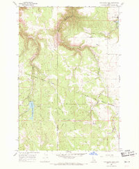
1968 Map of Winchester West
USGS Topo · Published 1971About this map
Winchester sits at the edge of this Lewis County plateau, adjacent to the recreational waters of Lapwai Lake and the grounds of Winchester State Park. The landscape is defined by the steep descents into the Mission Creek and Webb Creek drainages, showing a terrain heavily influenced by timber and water management. An Old Railroad Grade winds through the northern and central sections, tracing a path through the timbered hills that once connected these uplands to larger commercial networks. The southern portion of the map is anchored by the Soldiers Meadow Reservoir, a significant water feature near the Nez Perce Indian Reservation Boundary. Throughout the area, numerous unnamed Jeep Trails and forest tracks branch off from Forest, reflecting the region's reliance on secondary roads for land access and resource management during the late 1960s.
Find a feature on this map
15 named features on this map. Tap any name to fly to it.
Don’t see what you’re looking for? This feature index may not catch every label — zoom into the map to look around manually.
Map Details
Editions of this 1968 Winchester West Map
This is the sole edition of this map. No revisions or reprints were ever made.
Other maps of this area

1946 · Limekiln Rapids
USGS Topo · 1:62,500

1955 · Pullman
USGS Topo · 1:250,000

1958 · Pullman
USGS Topo · 1:250,000

1958 · Sweetwater
USGS Topo · 1:24,000

1958 · Lewiston Orchards
USGS Topo · 1:62,500

1958 · Culdesac
USGS Topo · 1:62,500

1967 · Hoover Point
USGS Topo · 1:24,000

1967 · Westlake
USGS Topo · 1:24,000
1967 · Winchester East
USGS Topo · 1:24,000

1968 · Waha
USGS Topo · 1:24,000