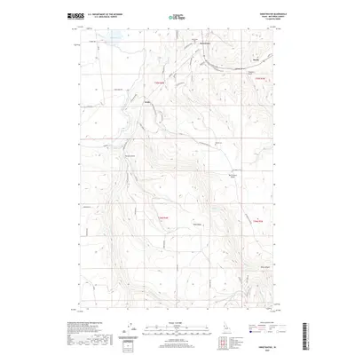
2020 Map of Sweetwater
USGS Topo · Published 2020About this map
Sweetwater and the surrounding high country of Nez Perce County are defined by a complex network of waterways and ridges in this 2020 study. The community of Webb sits at a junction of hydraulic engineering, where the Sweetwater Canal and Webb Cr Canal divert water across the dissected terrain. These systems, alongside Mann Lake, illustrate the vital importance of water management in the Lapwai Valley and the smaller drainages of Packers Gulch and Thiessen Gulch. Local history is anchored by the Sweetwater Cem and Red Elk Cem, while family-named landmarks such as McCormack Ridge and Webb Ridge trace the area's agricultural and ranching lineage. The map details a transition from the structured plots near the Lapwai Cr to the more isolated canyons of Polly Canyon and the eastern settlement of Bundy.
Find a feature on this map
50 named features on this map. Tap any name to fly to it.
Don’t see what you’re looking for? This feature index may not catch every label — zoom into the map to look around manually.
Map Details
Editions of this 2020 Sweetwater Map
This is the sole edition of this map. No revisions or reprints were ever made.
Other maps of this area

1946 · Limekiln Rapids
USGS Topo · 1:62,500

1955 · Pullman
USGS Topo · 1:250,000

1958 · Pullman
USGS Topo · 1:250,000

1958 · Lapwai
USGS Topo · 1:24,000

1958 · Sweetwater
USGS Topo · 1:24,000

1958 · Lewiston Orchards North
USGS Topo · 1:24,000

1958 · Lewiston Orchards South
USGS Topo · 1:24,000

1958 · Lewiston Orchards
USGS Topo · 1:62,500

1958 · Culdesac
USGS Topo · 1:62,500

1968 · Waha
USGS Topo · 1:24,000