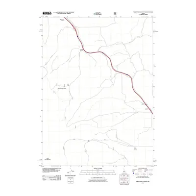
2011 Map of Sweetzer Canyon
USGS Topo · Published 2011About this map
Sweetzer Canyon and the northern slopes of the Black Pine Mountains define this landscape in Cassia County. In this high-elevation rangeland, life and transit revolve around the few reliable water sources and the natural corridors carved through the hills. The map highlights the seasonal importance of Meadow Creek and the localized reach of Mud Springs. A network of Forest Service and local access roads, including Sweetzer Rd and Juniper Rd, snake through the terrain, connecting several prominent topographic features such as Mortenson Canyon, Burnt Canyon, and Jones Canyon. The arrangement of these roads and named canyons suggests a landscape shaped by ranching and resource management, where family-named landmarks like Mortenson Canyon or the drainage at Mill Fork indicate a history of local land use and geographic orientation.
Find a feature on this map
16 named features on this map. Tap any name to fly to it.
Don’t see what you’re looking for? This feature index may not catch every label — zoom into the map to look around manually.
Map Details
Editions of this 2011 Sweetzer Canyon Map
This is the sole edition of this map. No revisions or reprints were ever made.
Other maps of this area

1954 · Pocatello
USGS Topo · 1:250,000

1958 · Pocatello
USGS Topo · 1:250,000

1958 · Sublett
USGS Topo · 1:62,500

1959 · Strevell
USGS Topo · 1:62,500

1973 · Juniper
USGS Topo · 1:24,000

1973 · Sublett Troughs
USGS Topo · 1:24,000

1973 · Black Pine
USGS Topo · 1:24,000
1984 · Malad City
USGS Topo · 1:100,000
1985 · Sandrock Canyon
USGS Topo · 1:24,000
1985 · Strevell
USGS Topo · 1:24,000