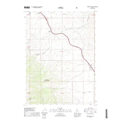
2020 Map of Sweetzer Canyon
USGS Topo · Published 2020About this map
Sawtooth National Forest dominates the southern landscape of this Cassia County region, where the high elevations of the Black Pine Mountains culminate at War Eagle Peak. This high-desert terrain is defined by a series of dramatic drainages including Sweetzer Canyon, Hutchey Canyon, and Burnt Canyon. The map reveals a network of land management and access routes, such as Juniper Rd and the Pipeline Jeep Trail, which facilitate movement through the disparate elevations of Juniper Valley. Water sources are sparse but critical, marked by Meadow Cr and Mud Spring. The structural layout of townships and ranges indicates the systematic surveying of this Idaho back-country, where the primary human footprint is found in the development of forest roads like Pole Canyon Rd 761 and Nat For Dev Rd 768.
Find a feature on this map
31 named features on this map. Tap any name to fly to it.
Don’t see what you’re looking for? This feature index may not catch every label — zoom into the map to look around manually.
Map Details
Editions of this 2020 Sweetzer Canyon Map
This is the sole edition of this map. No revisions or reprints were ever made.
Other maps of this area

1954 · Pocatello
USGS Topo · 1:250,000

1958 · Pocatello
USGS Topo · 1:250,000

1958 · Sublett
USGS Topo · 1:62,500

1959 · Strevell
USGS Topo · 1:62,500

1973 · Juniper
USGS Topo · 1:24,000

1973 · Sublett Troughs
USGS Topo · 1:24,000

1973 · Black Pine
USGS Topo · 1:24,000
1984 · Malad City
USGS Topo · 1:100,000
1985 · Sandrock Canyon
USGS Topo · 1:24,000
1985 · Strevell
USGS Topo · 1:24,000