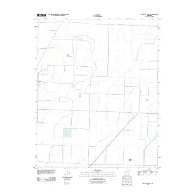
2011 Map of Swifton East
USGS Topo · Published 2011About this map
Swifton anchors the western edge of this 2011 landscape, where the agricultural plains of Jackson County meet a complex network of managed waterways. The terrain is defined by its drainage history, featuring prominent channels like Maple Ditch, Deep Ditch, and Willow Ditch that lace the fields between larger natural features. The Cache River flows through the southeastern corner, bordered by Denton Island and the meandering Worthington Slough. Local family history is centered on the Arnold Cemetery near Arnold Rd and Worley Cemetery to the east, offering specific points of interest for genealogists tracing regional roots. The map reveals a high density of rural infrastructure, from the long stretches of Jackson Road 74 to naming conventions that reflect local landowners, such as Ernest Smith Rd and Tommy Harvey Rd.
Find a feature on this map
46 named features on this map. Tap any name to fly to it.
Don’t see what you’re looking for? This feature index may not catch every label — zoom into the map to look around manually.
Map Details
Editions of this 2011 Swifton East Map
This is the sole edition of this map. No revisions or reprints were ever made.
Other maps of this area

1935 · Sedgwick
USGS Topo · 1:62,500

1935 · Alicia
USGS Topo · 1:62,500

1935 · Tuckerman
USGS Topo · 1:62,500

1939 · Weiner
USGS Topo · 1:62,500

1953 · Memphis
USGS Topo · 1:250,000

1956 · Memphis
USGS Topo · 1:250,000

1959 · Weiner
USGS Topo · 1:62,500

1959 · Sedgwick
USGS Topo · 1:62,500

1960 · Weiner
USGS Topo · 1:62,500
1960 · Sedgwick
USGS Topo · 1:62,500