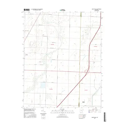
2017 Map of Swifton East
USGS Topo · Published 2017About this map
Village Cr and Willow Ditch carve a complex network of drainage across this low-lying stretch of eastern Jackson County, reflecting the deep-seated efforts to manage the wetlands of the Mississippi Alluvial Plain. The settlement of Swifton sits on the western edge of the quadrangle, while the smaller community of Denton Island is located near the southeastern corner along the Cache River. This 2017 survey illustrates the agricultural modernization of the region, where once-winding waterways have been straightened into channels like Deep Ditch and Maple Ditch to support the surrounding farmland.
Find a feature on this map
48 named features on this map. Tap any name to fly to it.
Don’t see what you’re looking for? This feature index may not catch every label — zoom into the map to look around manually.
Map Details
Editions of this 2017 Swifton East Map
This is the sole edition of this map. No revisions or reprints were ever made.
Other maps of this area

1935 · Sedgwick
USGS Topo · 1:62,500

1935 · Alicia
USGS Topo · 1:62,500

1935 · Tuckerman
USGS Topo · 1:62,500

1939 · Weiner
USGS Topo · 1:62,500

1953 · Memphis
USGS Topo · 1:250,000

1956 · Memphis
USGS Topo · 1:250,000

1959 · Weiner
USGS Topo · 1:62,500

1959 · Sedgwick
USGS Topo · 1:62,500

1960 · Weiner
USGS Topo · 1:62,500
1960 · Sedgwick
USGS Topo · 1:62,500