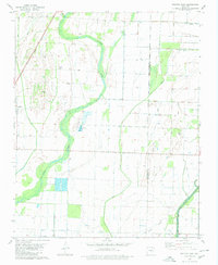
1980 Map of Swifton East
USGS Topo · Published 1980About this map
Village Creek meanders through the lowlands of the Arkansas delta, defining the agricultural landscape of Jackson and Craighead Counties. Near the town of Swifton, the Missouri Pacific railroad corridor runs parallel to the creek, serving as the primary transportation artery for this farming region. The land is marked by small-scale industrial and commercial operations, including a Gravel Pit and a specialized Fish Farm, which indicate how the local economy utilized the flat, water-rich terrain during the late 1970s.
Find a feature on this map
18 named features on this map. Tap any name to fly to it.
Don’t see what you’re looking for? This feature index may not catch every label — zoom into the map to look around manually.
Map Details
Editions of this 1980 Swifton East Map
This is the sole edition of this map. No revisions or reprints were ever made.
Other maps of this area

1935 · Sedgwick
USGS Topo · 1:62,500

1935 · Alicia
USGS Topo · 1:62,500

1935 · Tuckerman
USGS Topo · 1:62,500

1939 · Weiner
USGS Topo · 1:62,500

1953 · Memphis
USGS Topo · 1:250,000

1956 · Memphis
USGS Topo · 1:250,000

1959 · Weiner
USGS Topo · 1:62,500

1959 · Sedgwick
USGS Topo · 1:62,500

1960 · Weiner
USGS Topo · 1:62,500
1960 · Sedgwick
USGS Topo · 1:62,500