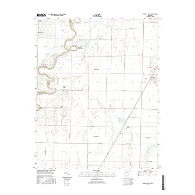
2017 Map of Swifton West
USGS Topo · Published 2017About this map
The Black River snakes through the western portion of this landscape, defining a complex network of wetlands and meanders such as Perkins Bend, Running Water Bend, and Battle Axe Bend. This river system creates a distinct divide between the alluvial lowlands and the higher ground where settlements and cemeteries are concentrated. Near the eastern edge, the town of Swifton sits along the rail corridor, supported by local landmarks like Swifton Cem. The rural interior is dotted with small communities including Centerville, Kenyon, and Vance, which are anchored by numerous family and community burial grounds such as the Foust-Adams Family Cem and Bandy Cem. A sophisticated drainage system, featuring Tuckerman Ditch and Hatchet Ditch, manages the water levels of the surrounding terrain, while smaller water bodies like Round Lake and Cow Pond remain as remnants of the river's shifting course.
Find a feature on this map
64 named features on this map. Tap any name to fly to it.
Don’t see what you’re looking for? This feature index may not catch every label — zoom into the map to look around manually.
Map Details
Editions of this 2017 Swifton West Map
This is the sole edition of this map. No revisions or reprints were ever made.
Other maps of this area

1932 · Strawberry
USGS Topo · 1:62,500

1935 · Alicia
USGS Topo · 1:62,500

1935 · Strawberry
USGS Topo · 1:62,500

1935 · Newport
USGS Topo · 1:62,500

1935 · Tuckerman
USGS Topo · 1:62,500

1941 · Strawberry
USGS Topo · 1:62,500

1953 · Memphis
USGS Topo · 1:250,000

1955 · Strawberry
USGS Topo · 1:24,000

1955 · Cord
USGS Topo · 1:24,000

1956 · Memphis
USGS Topo · 1:250,000