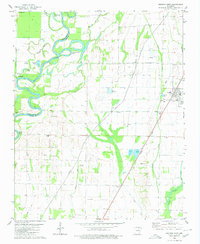
1980 Map of Swifton West
USGS Topo · Published 1980About this map
The Black River meanders sharply through the western portion of this terrain, defining the border between Independence and Jackson counties. This dynamic hydrological environment is marked by deep oxbows and sloughs, including Battle Axe Bend, Running Water Bend, and Horseshoe Lake. The landscape reflects a highly managed agricultural system where natural watercourses like Cattail Creek and Village Creek are integrated with an extensive network of drainage infrastructure, such as Tuckerman Ditch and Pompeys Ditch.
Find a feature on this map
37 named features on this map. Tap any name to fly to it.
Don’t see what you’re looking for? This feature index may not catch every label — zoom into the map to look around manually.
Map Details
Editions of this 1980 Swifton West Map
This is the sole edition of this map. No revisions or reprints were ever made.
Other maps of this area

1932 · Strawberry
USGS Topo · 1:62,500

1935 · Alicia
USGS Topo · 1:62,500

1935 · Strawberry
USGS Topo · 1:62,500

1935 · Newport
USGS Topo · 1:62,500

1935 · Tuckerman
USGS Topo · 1:62,500

1941 · Strawberry
USGS Topo · 1:62,500

1953 · Memphis
USGS Topo · 1:250,000

1955 · Strawberry
USGS Topo · 1:24,000

1955 · Cord
USGS Topo · 1:24,000

1956 · Memphis
USGS Topo · 1:250,000