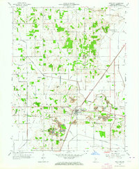
1963 Map of Switz City
USGS Topo · Published 1964About this map
The junction of the Pennsylvania and Illinois Central railroads defines the character of Switz City, a vital rail hub in Greene County during the early 1960s. This survey, revised from earlier planetary table mapping, captures a landscape undergoing significant transformation through surface mining. Extensive Strip Mines and a large Tipple located east of the city demonstrate the dominance of the coal industry, while numerous Gas Wells are scattered across the surrounding townships of Grant and Fairplay. Local family history is preserved in a dense network of burial grounds, including the Bohley, Britton, and Waggoner cemeteries. Beyond the industrial zones, the map shows the rural infrastructure of the era, from the Linton Airport on the western edge to the network of drainage canals like Letsinger Ditch and Fourmile Ditch that managed the low-lying terrain near Lattas Creek.
Find a feature on this map
45 named features on this map. Tap any name to fly to it.
Don’t see what you’re looking for? This feature index may not catch every label — zoom into the map to look around manually.
Map Details
Editions of this 1963 Switz City Map
3 editions found
Other maps of this area

1908 · Bloomfield
USGS Topo · 1:62,500

1938 · Coal City
USGS Topo · 1:24,000

1938 · Switz City
USGS Topo · 1:24,000

1940 · Linton
USGS Topo · 1:24,000

1940 · Jasonville
USGS Topo · 1:24,000

1943 · Lyons
USGS Topo · 1:24,000

1943 · Sandborn
USGS Topo · 1:24,000

1947 · Switz City
USGS Topo · 1:24,000

1947 · Linton
USGS Topo · 1:24,000

1948 · Coal City
USGS Topo · 1:24,000