
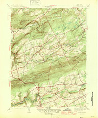
1946 Map of Sybertsville
USGS Topo · Published 1946About this map
Nescopeck Mountain divides this region of Luzerne County, separating the southern settlements in Sugarloaf and Butler townships from the creek-valleys to the north. The landscape is dotted with early mid-century rural institutions, including a high concentration of named schoolhouses such as the Red Sch, Whitebread Sch, and Kinsey Sch. These small educational hubs, along with St James Ch, reflect the distributed nature of the farming and timber communities before mid-century consolidation.
Find a feature on this map
33 named features on this map. Tap any name to fly to it.
Don’t see what you’re looking for? This feature index may not catch every label — zoom into the map to look around manually.
Map Details
Editions of this 1946 Sybertsville Map
2 editions found
Other maps of this area

1889 · Hazleton
USGS Topo · 1:62,500

1891 · Wilkesbarre
USGS Topo · 1:62,500

1891 · Hazleton
USGS Topo · 1:62,500

1892 · Mahanoy
USGS Topo · 1:62,500

1893 · Hazleton
USGS Topo · 1:62,500

1893 · Mahanoy
USGS Topo · 1:62,500

1894 · Shickshinny
USGS Topo · 1:62,500

1894 · Wilkesbarre
USGS Topo · 1:62,500

1943 · Scranton
USGS Topo · 1:125,000

1944 · Newark
USGS Topo · 1:250,000
Featured Places
- Dorrance Township, PA
- Conyngham Township, PA
- Slocum Township, PA
- Nescopeck Township, PA
- Butler Township, PA