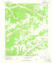
1971 Map of Sycamore
USGS Topo · Published 1973About this map
Sycamore serves as a small anchor point in this corner of Northeast Oklahoma, where the landscape transitions from the wooded drainage of Yellow Bird Hollow to the open expanses of Wet Prairie. In the early 1970s, the rural character of Delaware County is evident in the network of country churches that dot the hills and valleys, including Poynor Ch, Oak Chapel, and Mt Herman Ch. These landmarks, along with Indianola Cem and Ward Cem, highlight the established community roots that have persisted as the land was settled around major waterways like Whitewater Creek and Beaty Creek. The presence of a Substa near the town center indicates the creeping modernization of the electrical grid into this agricultural and wooded terrain during the late twentieth century.
Find a feature on this map
16 named features on this map. Tap any name to fly to it.
Don’t see what you’re looking for? This feature index may not catch every label — zoom into the map to look around manually.
Map Details
Editions of this 1971 Sycamore Map
This is the sole edition of this map. No revisions or reprints were ever made.
Other maps of this area

1899 · Siloam Springs
USGS Topo · 1:125,000

1903 · Siloam Springs
USGS Topo · 1:125,000

1904 · Siloam Springs
USGS Topo · 1:125,000

1907 · Wyandotte
USGS Topo · 1:125,000

1909 · Wyandotte
USGS Topo · 1:125,000

1954 · Tulsa
USGS Topo · 1:250,000

1958 · Tulsa
USGS Topo · 1:250,000

1963 · Tulsa
USGS Topo · 1:250,000

1964 · Dodge
USGS Topo · 1:24,000
1965 · South West City
USGS Topo · 1:24,000