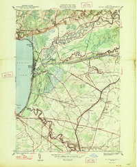
1947 Map of Sylvan Beach
USGS Topo · Published 1947About this map
The eastern shores of Oneida Lake and the confluence of the Barge Canal with local waterways define this mid-century portrait of a region shaped by transport and seasonal recreation. Sylvan Beach and Edgewater Beach serve as the primary lakefront settlements, while the interior is dotted with small rural hubs such as Fish Creek Landing and Higginsville. The map reveals a transition in mobility, capturing the New York Central and Western railroad corridors alongside traditional water routes like Fish Creek and Wood Creek. Local history and genealogy interest is high throughout the rural landscape, which is anchored by several family and community landmarks. Researchers can identify numerous schoolhouses, including Stone School and Havener Sch, and quiet country congregations like Irish Ridge Ch. Several small burial grounds, such as Murray Cem and Extater Cem, mark the legacy of early families in the town of Vienna and the surrounding townships.
Find a feature on this map
42 named features on this map. Tap any name to fly to it.
Don’t see what you’re looking for? This feature index may not catch every label — zoom into the map to look around manually.
Map Details
Editions of this 1947 Sylvan Beach Map
This is the sole edition of this map. No revisions or reprints were ever made.
Other maps of this area

1895 · Chittenango
USGS Topo · 1:62,500

1895 · Oneida
USGS Topo · 1:62,500

1898 · Oneida
USGS Topo · 1:62,500

1898 · Chittenango
USGS Topo · 1:62,500

1902 · Chittenango
USGS Topo · 1:62,500

1902 · Oneida
USGS Topo · 1:62,500

1905 · Taberg
USGS Topo · 1:62,500

1906 · Kasoag
USGS Topo · 1:62,500

1939 · Oneida
USGS Topo · 1:62,500

1941 · Jewell
USGS Topo · 1:24,000