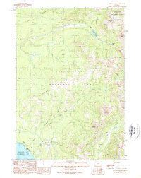
1989 Map of Sylvan Lake
USGS Topo · Published 1989About this map
The high-elevation interface of Yellowstone National Park and the Shoshone National Forest dominates this provisional study, captured just years before the turn of the millennium. The landscape is defined by the Absaroka Range, where peaks like Mount Stevenson and Mount Doane overlook the Southeast Arm of Yellowstone Lake. Of particular interest to geothermal researchers are several designated Thermal Areas and the Brimstone Basin, illustrating the active volcanic nature of the region. The map highlights the primitive infrastructure of the wilderness, from the Thorofare Trail following the shoreline to the Sylvan Pass road. Small bodies of water such as Sylvan Lake and Eleanor Lake sit nestled between high summits like Avalanche Peak and Grizzly Peak, marking the drainage divides for Clear Creek and Columbine Creek.
Find a feature on this map
26 named features on this map. Tap any name to fly to it.
Don’t see what you’re looking for? This feature index may not catch every label — zoom into the map to look around manually.
Map Details
Editions of this 1989 Sylvan Lake Map
This is the sole edition of this map. No revisions or reprints were ever made.
Other maps of this area

1885 · Lake
USGS Topo · 1:125,000

1886 · Canyon
USGS Topo · 1:125,000

1895 · Canyon
USGS Topo · 1:125,000

1895 · Lake
USGS Topo · 1:125,000

1896 · Lake
USGS Topo · 1:125,000

1896 · Canyon
USGS Topo · 1:125,000

1901 · Canyon
USGS Topo · 1:125,000

1901 · Lake
USGS Topo · 1:125,000

1906 · Lake
USGS Topo · 1:125,000

1907 · Canyon
USGS Topo · 1:125,000