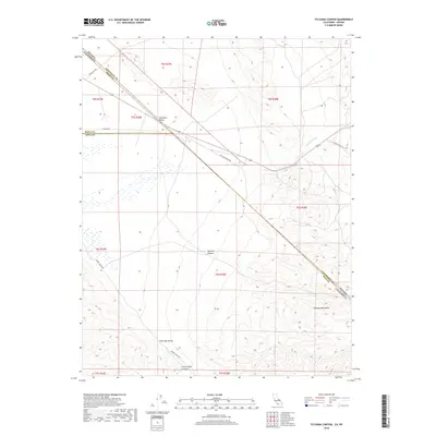
2018 Map of Sylvania Canyon
USGS Topo · Published 2018About this map
The Sylvania Mountains dominate this high-desert landscape where Inyo County, California meets Esmeralda County, Nevada. This arid basin and range geography is defined by the sweeping Fish Lake Valley and the steep incisions of Sylvania Canyon. The map reveals a network of remote access routes used for mineral exploration and trans-border travel, including Savinion Mining Rd and the aptly named State Line Rd. Ephemeral watercourses such as Palmetto Wash and Willow Wash mark the drainage patterns through the alluvial fans. In the southern portion, Horse Thief Canyon and Eureka Valley Rd suggest a history of passage through these difficult corridors, providing an essential record for those studying the mining and transport routes of the northern Mojave borderlands.
Find a feature on this map
21 named features on this map. Tap any name to fly to it.
Don’t see what you’re looking for? This feature index may not catch every label — zoom into the map to look around manually.
Map Details
Editions of this 2018 Sylvania Canyon Map
This is the sole edition of this map. No revisions or reprints were ever made.
Other maps of this area

1898 · Silver Peak
USGS Topo · 1:125,000

1900 · Silver Peak
USGS Topo · 1:125,000

1908 · Lida
USGS Topo · 1:250,000

1913 · Lida
USGS Topo · 1:250,000

1954 · Goldfield
USGS Topo · 1:250,000

1955 · Goldfield
USGS Topo · 1:250,000

1957 · Magruder Mtn
USGS Topo · 1:62,500

1958 · Goldfield
USGS Topo · 1:250,000

1958 · Soldier Pass
USGS Topo · 1:62,500

1962 · Goldfield
USGS Topo · 1:250,000