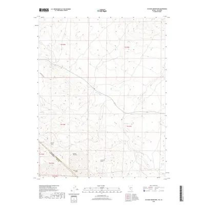
2018 Map of Sylvania Mountains
USGS Topo · Published 2018About this map
Sylvania Mountains dominate this high-desert terrain where the California and Nevada border cuts through the southeastern corner of the quadrangle. The map captures a landscape defined by deep drainages and vital water sources, with Sylvania Canyon and Cucomungo Canyon carving through the mountain range. Access through this arid region is limited, primarily following the course of Palmetto Wash or the historic corridor of Pigeon Springs Rd. Small, isolated water points such as Pigeon Spring, Mud Spring, and Lida Spring serve as critical landmarks for navigation and local history. The convergence of Esmeralda and Inyo counties at the state line highlights the jurisdictional complexity of this remote boundary area, while White Cliff Canyon provides a distinct geographic reference point in the southern reaches of the range.
Find a feature on this map
17 named features on this map. Tap any name to fly to it.
Don’t see what you’re looking for? This feature index may not catch every label — zoom into the map to look around manually.
Map Details
Editions of this 2018 Sylvania Mountains Map
This is the sole edition of this map. No revisions or reprints were ever made.
Other maps of this area

1898 · Silver Peak
USGS Topo · 1:125,000

1900 · Silver Peak
USGS Topo · 1:125,000

1908 · Lida
USGS Topo · 1:250,000

1913 · Lida
USGS Topo · 1:250,000

1954 · Goldfield
USGS Topo · 1:250,000

1955 · Goldfield
USGS Topo · 1:250,000

1957 · Magruder Mtn
USGS Topo · 1:62,500

1958 · Goldfield
USGS Topo · 1:250,000

1958 · Soldier Pass
USGS Topo · 1:62,500

1962 · Goldfield
USGS Topo · 1:250,000