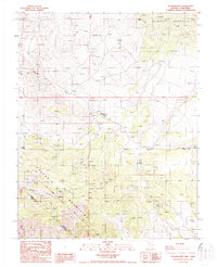
1987 Map of Sylvania Mts
USGS Topo · Published 1987About this map
Mining operations and historical boundaries define this high-altitude landscape along the Nevada-California border in the late 1980s. The region is centered on the Palmetto Mountains and Sylvania Mountains, where the Von Schmidt Line marks a significant historical surveying boundary. Prospectors and mining companies left a dense footprint here, visible through the Palmetto Mine, the Sylvania Mine, and numerous Open Pit Mines scattered across the slopes.
Find a feature on this map
22 named features on this map. Tap any name to fly to it.
Don’t see what you’re looking for? This feature index may not catch every label — zoom into the map to look around manually.
Map Details
Editions of this 1987 Sylvania Mts Map
This is the sole edition of this map. No revisions or reprints were ever made.
Other maps of this area

1898 · Silver Peak
USGS Topo · 1:125,000

1900 · Silver Peak
USGS Topo · 1:125,000

1908 · Lida
USGS Topo · 1:250,000

1913 · Lida
USGS Topo · 1:250,000

1954 · Goldfield
USGS Topo · 1:250,000

1955 · Goldfield
USGS Topo · 1:250,000

1957 · Magruder Mtn
USGS Topo · 1:62,500

1958 · Goldfield
USGS Topo · 1:250,000

1958 · Soldier Pass
USGS Topo · 1:62,500

1962 · Goldfield
USGS Topo · 1:250,000