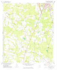
1978 Map of Sylvania South
USGS Topo · Published 1978About this map
The southern portion of Sylvania serves as the primary hub on this late 1970s topographical survey, where the Central of Georgia railroad tracks intersect with established regional highways. Moving away from the town, the landscape transitions into a network of small agricultural settlements and family-named landmarks. The area is dotted with numerous country churches and burial grounds, such as Double Heads Ch and the Zeigler Cem, which provide significant data points for local genealogy.
Find a feature on this map
38 named features on this map. Tap any name to fly to it.
Don’t see what you’re looking for? This feature index may not catch every label — zoom into the map to look around manually.
Map Details
Editions of this 1978 Sylvania South Map
This is the sole edition of this map. No revisions or reprints were ever made.
Other maps of this area

1918 · Oliver
USGS Topo · 1:62,500

1920 · Hilltonia
USGS Topo · 1:62,500

1920 · Millen
USGS Topo · 1:62,500

1920 · Oliver
USGS Topo · 1:62,500

1921 · Rocky Ford
USGS Topo · 1:62,500

1943 · Hilltonia
USGS Topo · 1:62,500

1943 · Rocky Ford
USGS Topo · 1:62,500

1943 · Millen
USGS Topo · 1:62,500

1943 · Millen
USGS Topo · 1:125,000

1943 · Oliver
USGS Topo · 1:62,500