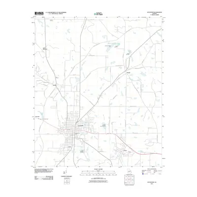
2011 Map of Sylvester
USGS Topo · Published 2011About this map
Sylvester serves as the central hub of Worth County in this modern survey, surrounded by a network of smaller communities including Poulan, Isabella, and Shingler. The landscape is defined by the convergence of several waterways, such as Warrior Creek, Horse Creek, and Ty Ty Creek, which are supplemented by numerous small man-made lakes and dams like the City of Sylvester Lake Dam. Local history and genealogy are well-represented by several established burial grounds, notably Hillcrest Cemetery and Antioch Cemetery. The grid-like patterns of rural roads, such as Isabella Terrell Rd and Old Mail Rd, reflect the agricultural organization of the region. These routes connect various residential pockets and civic locations like the Sylvester Post Office, illustrating the continued importance of these traditional South Georgia settlements as they transitioned into the early twenty-first century.
Find a feature on this map
69 named features on this map. Tap any name to fly to it.
Don’t see what you’re looking for? This feature index may not catch every label — zoom into the map to look around manually.
Map Details
Editions of this 2011 Sylvester Map
This is the sole edition of this map. No revisions or reprints were ever made.
Other maps of this area

1953 · Waycross
USGS Topo · 1:250,000

1956 · Sylvester
USGS Topo · 1:62,500

1956 · Doerun
USGS Topo · 1:62,500

1958 · Waycross
USGS Topo · 1:250,000

1972 · Cuffietown
USGS Topo · 1:24,000

1973 · Sumner
USGS Topo · 1:24,000

1973 · Ty Ty
USGS Topo · 1:24,000
1973 · Acree
USGS Topo · 1:24,000

1973 · Sylvester
USGS Topo · 1:24,000
1973 · Doles
USGS Topo · 1:24,000