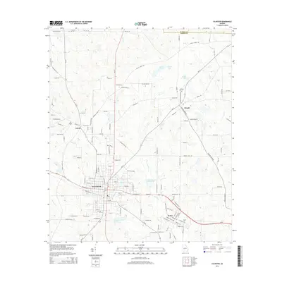
2014 Map of Sylvester
USGS Topo · Published 2014About this map
Sylvester serves as the central hub of this Worth County landscape, where the confluence of GA-33, GA-112, and the Us-82 corridor defines the regional transportation network. The settlement pattern reflects a deeply rooted agricultural and local history, anchored by the nearby community of Isabella to the northwest and Poulan to the southeast. The terrain is characterized by the drainages of Warrior Cr and Ty Ty Cr, which feed various water bodies including Odum Lake and the City of Sylvester Lake. Genealogists will find significant value in the distribution of local burial grounds, such as Hillcrest Cem and Isabella Cem, alongside smaller rural sites like Antioch Cem and Pleasant Grove Cem. The map captures the transition from the concentrated residential blocks of the county seat to the outlying farmsteads and junctions like Shingler, providing a clear record of South Georgia's land use in the early 21st century.
Find a feature on this map
132 named features on this map. Tap any name to fly to it.
Don’t see what you’re looking for? This feature index may not catch every label — zoom into the map to look around manually.
Map Details
Editions of this 2014 Sylvester Map
This is the sole edition of this map. No revisions or reprints were ever made.
Other maps of this area

1953 · Waycross
USGS Topo · 1:250,000

1956 · Sylvester
USGS Topo · 1:62,500

1956 · Doerun
USGS Topo · 1:62,500

1958 · Waycross
USGS Topo · 1:250,000

1972 · Cuffietown
USGS Topo · 1:24,000

1973 · Sumner
USGS Topo · 1:24,000

1973 · Ty Ty
USGS Topo · 1:24,000
1973 · Acree
USGS Topo · 1:24,000

1973 · Sylvester
USGS Topo · 1:24,000
1973 · Doles
USGS Topo · 1:24,000