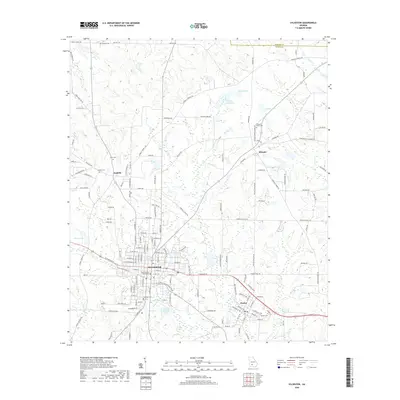
2020 Map of Sylvester
USGS Topo · Published 2020About this map
The Worth County Courthouse stands as the central landmark of Sylvester, the county seat where historic street grids meet modern thoroughfares. This portion of South Georgia shows a transition from the structured residential blocks of Sylvester and Poulan to the surrounding agricultural landscape marked by family-named roads like Isabella Terrell Rd and Houston Farm Rd. To the north, the small settlement of Isabella remains a point of interest for local historians, situated near the headwaters of Horse Cr and several legacy family burial grounds, including Isabella Cem and Sikes Cem. The landscape is well-watered by a network of creeks such as Warrior Cr and Ty Ty Cr, alongside recreational and agricultural water bodies like Knight Lake and the City of Sylvester Lake, illustrating the region's reliance on its drainage basins for both community identity and land use.
Find a feature on this map
153 named features on this map. Tap any name to fly to it.
Don’t see what you’re looking for? This feature index may not catch every label — zoom into the map to look around manually.
Map Details
Editions of this 2020 Sylvester Map
This is the sole edition of this map. No revisions or reprints were ever made.
Other maps of this area

1953 · Waycross
USGS Topo · 1:250,000

1956 · Sylvester
USGS Topo · 1:62,500

1956 · Doerun
USGS Topo · 1:62,500

1958 · Waycross
USGS Topo · 1:250,000

1972 · Cuffietown
USGS Topo · 1:24,000

1973 · Sumner
USGS Topo · 1:24,000

1973 · Ty Ty
USGS Topo · 1:24,000
1973 · Acree
USGS Topo · 1:24,000

1973 · Sylvester
USGS Topo · 1:24,000
1973 · Doles
USGS Topo · 1:24,000