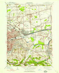
1938 Map of Syracuse East
USGS Topo · Published 1953About this map
The industrial and suburban expansion of eastern Syracuse is evident in this late-1930s survey, showing a landscape defined by massive rail infrastructure and evolving transit corridors. The New York Central railroad dominates the geography east of Eastwood, featuring extensive yards that fueled the region's economy. Concurrent with this heavy industry, the map captures established community landmarks like the Orphans Home and St Marys Cemetery, alongside the emerging residential character of East Syracuse and Fayetteville.
Find a feature on this map
63 named features on this map. Tap any name to fly to it.
Don’t see what you’re looking for? This feature index may not catch every label — zoom into the map to look around manually.
Map Details
Editions of this 1938 Syracuse East Map
2 editions found
Other maps of this area

1895 · Chittenango
USGS Topo · 1:62,500

1895 · Syracuse
USGS Topo · 1:62,500

1897 · Cazenovia
USGS Topo · 1:62,500

1898 · Syracuse
USGS Topo · 1:62,500

1898 · Chittenango
USGS Topo · 1:62,500

1899 · Cazenovia
USGS Topo · 1:62,500

1900 · Tully
USGS Topo · 1:62,500

1902 · Chittenango
USGS Topo · 1:62,500

1938 · Syracuse East
USGS Topo · 1:24,000

1939 · Syracuse West
USGS Topo · 1:24,000