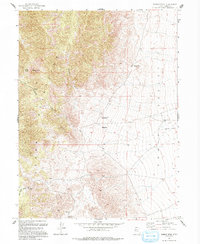
1993 Map of Tabbys Peak
USGS Topo · Published 1993About this map
Tabbys Peak serves as the focal point of this arid landscape, anchoring the eastern slopes of the Cedar Mountains as they descend into the broad expanse of Skull Valley. The terrain is defined by a series of high ridges and narrow drainages like Wildcat Canyon, which opens into the low-lying Wildcat Basin. This 1993 edition, compiled from earlier 1950s aerial photography and updated in the late 1980s, reveals a remote environment where water sources such as Tabbys Spring and Cochran Spring were vital for the survival of ranching or transit efforts in the desert. An Old Railroad Grade cuts through the valley floor to the east, marking the legacy of regional industrial transport. High mountain transitions are recorded at Rydalch Pass and Six Horse Pass, while isolated signs of mineral exploration appear at a solitary Prospect.
Find a feature on this map
15 named features on this map. Tap any name to fly to it.
Don’t see what you’re looking for? This feature index may not catch every label — zoom into the map to look around manually.
Map Details
Editions of this 1993 Tabbys Peak Map
This is the sole edition of this map. No revisions or reprints were ever made.
Other maps of this area

1885 · Tooele Valley
USGS Topo · 1:250,000

1953 · Tooele
USGS Topo · 1:250,000

1955 · Tabbys Peak SE
USGS Topo · 1:24,000

1955 · Tabbys Peak
USGS Topo · 1:24,000

1955 · Wig Mtn
USGS Topo · 1:24,000

1955 · Wig Mtn NE
USGS Topo · 1:24,000

1955 · Tabbys Peak SW
USGS Topo · 1:24,000

1955 · Tooele
USGS Topo · 1:250,000

1973 · Quincy Spring
USGS Topo · 1:24,000

1973 · Aragonite SE
USGS Topo · 1:24,000