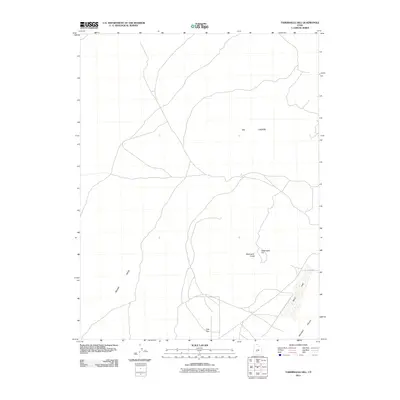
2011 Map of Tabernacle Hill
USGS Topo · Published 2011About this map
Tabernacle Hill and the adjacent Tabernacle Crater dominate this volcanic landscape within the larger Pahvant Valley. This 2011 survey by the U.S. Geological Survey documents a region shaped by geologic forces, where The Cinders and the elevated terrain of Beaver Ridge define the local topography. To the southeast, the ephemeral Mud Lake occupies a low point in the basin, illustrating the drainage patterns of the high desert. The map shows a sparse network of unpaved roads and tracks crossing Clay Flat, providing a detailed record of the access routes used for ranching or land management in this portion of Millard County. The lack of permanent structures highlights the utilitarian nature of the land, primarily focused on the natural features and wide-open valleys.
Find a feature on this map
7 named features on this map. Tap any name to fly to it.
Don’t see what you’re looking for? This feature index may not catch every label — zoom into the map to look around manually.
Map Details
Editions of this 2011 Tabernacle Hill Map
This is the sole edition of this map. No revisions or reprints were ever made.
Other maps of this area

1885 · Beaver
USGS Topo · 1:250,000

1885 · Sevier Desert
USGS Topo · 1:250,000

1953 · Richfield
USGS Topo · 1:250,000

1953 · Delta
USGS Topo · 1:250,000

1958 · Richfield
USGS Topo · 1:250,000

1958 · Delta
USGS Topo · 1:250,000

1960 · Meadow
USGS Topo · 1:24,000

1962 · Delta
USGS Topo · 1:250,000

1962 · Fillmore
USGS Topo · 1:62,500
1962 · The Sink
USGS Topo · 1:24,000