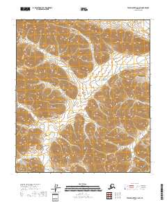
2018 Map of Table Mountain C-4 SW
USGS Topo · Published 2018About this map
E Fork Sheenjek River and the Coleen River define the hydrology of this high-latitude terrain within the North Slope Borough. The landscape is dominated by complex contour patterns that indicate significant elevation changes and drainage divides between these major watercourses. This area, mapped by the U.S. Geological Survey, represents a transition in the Arctic wilderness where the East Fork of the Sheenjek winds through the southwestern reaches of the quadrangle while the Coleen touches the northeastern corner. The absence of roads or permanent structures reflects the preservation of this remote interior, managed within the public land survey system as indicated by township boundaries like t10s r38e.
Find a feature on this map
9 named features on this map. Tap any name to fly to it.
Don’t see what you’re looking for? This feature index may not catch every label — zoom into the map to look around manually.
Map Details
Editions of this 2018 Table Mountain C-4 SW Map
This is the sole edition of this map. No revisions or reprints were ever made.
Other maps of this area

1951 · Table Mountain
USGS Topo · 1:250,000

1956 · Table Mountain
USGS Topo · 1:250,000

1964 · Table Mountain
USGS Topo · 1:250,000
1972 · Table Mountain B-4
USGS Topo · 1:63,360
1972 · Table Mountain B-5
USGS Topo · 1:63,360
1983 · Table Mountain C-5
USGS Topo · 1:63,360
1983 · Table Mountain C-4
USGS Topo · 1:63,360
2018 · Table Mountain C-4 NE
USGS Topo · 1:25,000
2018 · Table Mountain B-4 NE
USGS Topo · 1:25,000
2018 · Table Mountain C-4 SE
USGS Topo · 1:25,000