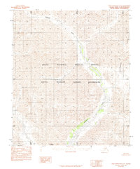
1983 Map of Table Mountain D-5
USGS Topo · Published 1984About this map
Sheenjek River flows through this interior section of the Arctic National Wildlife Refuge, carving a path through high-latitude wilderness before the turn of the twenty-first century. The map depicts a landscape where the Continental Divide dictates the drainage patterns of the north, marking a massive geographic boundary across the terrain. Within the Arctic Wildlife Refuge Wilderness, the topographic detail reveals landforms like Double Mountain, providing a technical look at a region defined by its lack of human infrastructure. This 1983 provisional edition, compiled from 1974 aerial photography, documents the untouched character of the North Slope Borough prior to modern developments, where the absence of roads emphasizes the primary role of natural features in defining the territory.
Find a feature on this map
5 named features on this map. Tap any name to fly to it.
Don’t see what you’re looking for? This feature index may not catch every label — zoom into the map to look around manually.
Map Details
Editions of this 1983 Table Mountain D-5 Map
2 editions found
Other maps of this area

1951 · Demarcation Point
USGS Topo · 1:250,000

1951 · Arctic
USGS Topo · 1:250,000

1951 · Table Mountain
USGS Topo · 1:250,000

1951 · Mt. Michelson
USGS Topo · 1:250,000

1955 · Demarcation Point
USGS Topo · 1:250,000

1956 · Table Mountain
USGS Topo · 1:250,000

1956 · Arctic
USGS Topo · 1:250,000

1956 · Mt. Michelson
USGS Topo · 1:250,000

1964 · Table Mountain
USGS Topo · 1:250,000

1964 · Demarcation Point
USGS Topo · 1:250,000