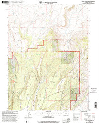
1998 Map of Table Mountain
USGS Topo · Published 2001About this map
The high-country terrain of the Wasatch National Forest dominates this Uinta County landscape, where the Mountain View Ranger District manages a complex geography of water and resource extraction. The area is defined by massive landforms like Table Mountain and Hickey Mountain, which drop away into drainage basins fed by Cottonwood Creek, Sage Creek, and the Henrys Fork. Resource development is a visible layer on this map, evidenced by a pipeline network, a Landing Strip, and several industrial sites including an Oil Well (Dry) and a Gravel Pit. The map captures a moment of modern land management where 4WD tracks and forest roads navigate between established hydrologic features like Big Spring and Whiskey Spring, reflecting a wilderness area utilized for both its natural resources and its watershed value.
Find a feature on this map
24 named features on this map. Tap any name to fly to it.
Don’t see what you’re looking for? This feature index may not catch every label — zoom into the map to look around manually.
Map Details
Editions of this 1998 Table Mountain Map
This is the sole edition of this map. No revisions or reprints were ever made.
Other maps of this area

1885 · Uinta
USGS Topo · 1:250,000

1905 · Gilbert Peak
USGS Topo · 1:125,000

1906 · Gilbert Peak
USGS Topo · 1:125,000

1954 · Salt Lake City
USGS Topo · 1:250,000

1954 · Ogden
USGS Topo · 1:250,000

1958 · Ogden
USGS Topo · 1:250,000

1958 · Salt Lake City
USGS Topo · 1:250,000

1960 · Ogden
USGS Topo · 1:250,000

1960 · Salt Lake City
USGS Topo · 1:250,000

1964 · Reed Reservoir
USGS Topo · 1:24,000