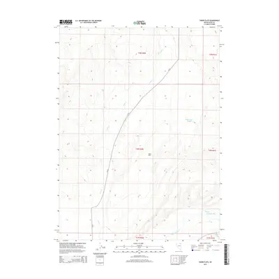
2015 Map of Tabor Flats
USGS Topo · Published 2015About this map
Tabor Flats defines the high-desert geography of this corner of Elko County, where the sprawling basin floor meets the drainage systems of northeastern Nevada. The Humboldt River cuts through the southern reaches of the map, joined by the confluence of Bishop Creek and Trout Creek. These water sources historically dictated the ranching and transit patterns of the region, visible here through the placement of Rabbit Creek Reservoir and the winding path of Tabor Creek. The landscape is etched by the straight lines of the Public Land Survey System, marking the township and range boundaries that have governed Nevada's land use for over a century. A singular thoroughfare, CR-753, provides the primary north-south transit corridor across the flats, following the natural contours of the valley floor.
Find a feature on this map
13 named features on this map. Tap any name to fly to it.
Don’t see what you’re looking for? This feature index may not catch every label — zoom into the map to look around manually.
Map Details
Editions of this 2015 Tabor Flats Map
This is the sole edition of this map. No revisions or reprints were ever made.
Other maps of this area

1955 · Wells
USGS Topo · 1:250,000

1958 · Wells
USGS Topo · 1:250,000

1961 · Wells
USGS Topo · 1:250,000

1967 · Black Butte SW
USGS Topo · 1:24,000

1967 · Black Butte
USGS Topo · 1:24,000

1967 · Hot Springs Creek
USGS Topo · 1:24,000

1967 · Welcome
USGS Topo · 1:24,000

1967 · Twin Buttes
USGS Topo · 1:24,000

1967 · Herder Creek
USGS Topo · 1:24,000
1967 · Deeth
USGS Topo · 1:24,000