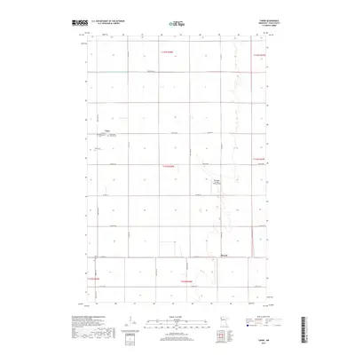
2019 Map of Tabor
USGS Topo · Published 2019About this map
The agrarian landscape of Polk County is defined by a rigid section grid and engineered waterways like Judicial Ditch Number Seventyfive. In the northwest corner, the small settlement of Tabor serves as a local focal point, characterized by its cluster of religious and burial sites including the Presbyterian Cem, Holy Trinity Catholic Cem, and the Tabor Cem. Further south, the community of Sherack is positioned near Holy Trinity Cem, illustrating the importance of these sites to the local genealogy of the region. The map reflects a modern rural environment where aviation meets agriculture at the Pulkrabek Private Landing Field. Transportation is dominated by a systematic network of county highways and local roads, such as Co HWY 23 and 380th Ave NW, which facilitate movement across the flat Minnesota prairie.
Find a feature on this map
33 named features on this map. Tap any name to fly to it.
Don’t see what you’re looking for? This feature index may not catch every label — zoom into the map to look around manually.
Map Details
Editions of this 2019 Tabor Map
This is the sole edition of this map. No revisions or reprints were ever made.
Other maps of this area

1918 · Angus
USGS Topo · 1:62,500

1918 · Warren
USGS Topo · 1:62,500

1952 · Grand Forks
USGS Topo · 1:250,000

1952 · Thief River Falls
USGS Topo · 1:250,000

1953 · Crookston
USGS Topo · 1:62,500

1955 · Warren
USGS Topo · 1:62,500

1956 · Thief River Falls
USGS Topo · 1:250,000

1956 · Grand Forks
USGS Topo · 1:250,000

1957 · Thief River Falls
USGS Topo · 1:250,000
1961 · Angus
USGS Topo · 1:24,000