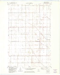
1982 Map of Tabor
USGS Topo · Published 1982About this map
The agrarian landscape of Tabor in Polk County is defined by a highly organized system of artificial waterways, reflecting the region's intensive engineering for drainage and cultivation. This 1982 map shows a network of channels including County Ditch No 7, Judicial Ditch No 75, and County Ditch No 41, which crisscross the flat terrain of Farley and Keystone townships. The map records the local cultural centers of the era, such as Holy Trinity Ch and the neighboring Holy Trinity Cem near the settlement of Sherack. To the north, the village of Tabor is anchored by the Tabor Cem. This survey also documents private aviation infrastructure with the Pulkrabek Landing Strip, illustrating the scale of individual agricultural operations in northern Minnesota during the late twentieth century.
Find a feature on this map
22 named features on this map. Tap any name to fly to it.
Don’t see what you’re looking for? This feature index may not catch every label — zoom into the map to look around manually.
Map Details
Editions of this 1982 Tabor Map
This is the sole edition of this map. No revisions or reprints were ever made.
Other maps of this area

1918 · Angus
USGS Topo · 1:62,500

1918 · Warren
USGS Topo · 1:62,500

1952 · Grand Forks
USGS Topo · 1:250,000

1952 · Thief River Falls
USGS Topo · 1:250,000

1953 · Crookston
USGS Topo · 1:62,500

1955 · Warren
USGS Topo · 1:62,500

1956 · Thief River Falls
USGS Topo · 1:250,000

1956 · Grand Forks
USGS Topo · 1:250,000

1957 · Thief River Falls
USGS Topo · 1:250,000
1961 · Angus
USGS Topo · 1:24,000