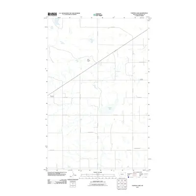
2011 Map of Tadpole Lake
USGS Topo · Published 2011About this map
Tadpole Lake sits at the heart of this northeastern Montana landscape, a prairie expanse characterized by a geometric grid of rural roads and scattered water features. The infrastructure of the area is defined by the Reed Number 2 Dam and a series of long-established section-line roads such as Blue Trail Rd and Cherry Creek Rd. The distribution of burial grounds throughout the countryside, including Saint Johns Cemetery in the west, Scandia Cemetery in the northeast, and Emmaus Cemetery in the southeast, points to the historical settlement patterns of the local farming community in Sheridan County. These named landmarks and transit corridors reflect a persistent agricultural layout where water management and community heritage remain the primary features of the physical geography.
Find a feature on this map
15 named features on this map. Tap any name to fly to it.
Don’t see what you’re looking for? This feature index may not catch every label — zoom into the map to look around manually.
Map Details
Editions of this 2011 Tadpole Lake Map
This is the sole edition of this map. No revisions or reprints were ever made.
Other maps of this area

1954 · Wolf Point
USGS Topo · 1:250,000

1958 · Wolf Point
USGS Topo · 1:250,000

1983 · Tadpole Lake
USGS Topo · 1:24,000

1983 · Dooley SE
USGS Topo · 1:24,000

1983 · Lone Tree Lake
USGS Topo · 1:24,000
1983 · Coalridge
USGS Topo · 1:24,000

1983 · Park Lake
USGS Topo · 1:24,000
1983 · Reserve NE
USGS Topo · 1:24,000

1983 · Westby South
USGS Topo · 1:24,000

1983 · Westby North
USGS Topo · 1:24,000