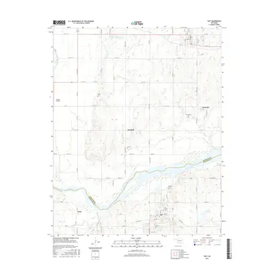
2016 Map of Taft
USGS Topo · Published 2016About this map
Taft and its surrounding rural communities occupy this landscape along the Arkansas River where the borders of Wagoner and Muskogee counties meet. The area is defined by its deep agricultural roots, seen in the wide Choska Bottom and the presence of scattered settlements such as Springhill, Clarksville, and Yahola. This 2016 survey is particularly valuable for genealogists, as it meticulously identifies numerous local burial sites including Choska Cem, Clarksville Cem, Van Cem, Blackjack Cem, and Taft Cem.
Find a feature on this map
34 named features on this map. Tap any name to fly to it.
Don’t see what you’re looking for? This feature index may not catch every label — zoom into the map to look around manually.
Map Details
Editions of this 2016 Taft Map
This is the sole edition of this map. No revisions or reprints were ever made.
Other maps of this area

1896 · Okmulgee
USGS Topo · 1:125,000

1900 · Okmulgee
USGS Topo · 1:125,000

1901 · Muscogee
USGS Topo · 1:125,000

1905 · Muscogee
USGS Topo · 1:125,000

1946 · Fort Smith
USGS Topo · 1:250,000

1948 · Keefeton
USGS Topo · 1:62,500

1948 · Wagoner
USGS Topo · 1:62,500

1950 · Keefeton
USGS Topo · 1:62,500

1950 · Wagoner
USGS Topo · 1:62,500
1963 · Red Bird
USGS Topo · 1:24,000