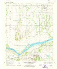
1971 Map of Taft
USGS Topo · Published 1973About this map
Arkansas River bottomlands define the landscape of this 1971 survey, where the river channel winds through Muskogee and Wagoner counties. The settlement of Taft is a focal point of the southern portion of the map, notably featuring the Oklahoma Childrens Center and the Texas and Pacific rail line. To the north, the town of Porter is situated along the Missouri-Kansas-Texas railroad, marking a period of established transport infrastructure. Family and local history are preserved in several burial grounds, including Choska Cem, Clarksville Cem, and Van Cem. The presence of the Yellow Water Ditch and extensive Choska Bottom agricultural lands indicates a highly managed riverine environment, where drainage and irrigation supported local farming near Gatesville and Springhill.
Find a feature on this map
30 named features on this map. Tap any name to fly to it.
Don’t see what you’re looking for? This feature index may not catch every label — zoom into the map to look around manually.
Map Details
Editions of this 1971 Taft Map
This is the sole edition of this map. No revisions or reprints were ever made.
Other maps of this area

1896 · Okmulgee
USGS Topo · 1:125,000

1900 · Okmulgee
USGS Topo · 1:125,000

1901 · Muscogee
USGS Topo · 1:125,000

1905 · Muscogee
USGS Topo · 1:125,000

1946 · Fort Smith
USGS Topo · 1:250,000

1948 · Keefeton
USGS Topo · 1:62,500

1948 · Wagoner
USGS Topo · 1:62,500

1950 · Keefeton
USGS Topo · 1:62,500

1950 · Wagoner
USGS Topo · 1:62,500
1963 · Red Bird
USGS Topo · 1:24,000