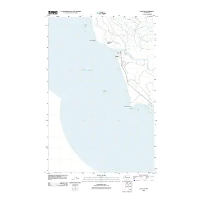
2011 Map of Taholah
USGS Topo · Published 2011About this map
Taholah serves as the primary coastal settlement on this portion of the Washington shoreline, situated where the Quinault River empties into the Pacific Ocean. This 2011 survey reveals the street layout of the village, featuring routes like Commuxi St, Cutan St, and Aalis Dr that provide access to the riverbank and the Quinault Road Bridge. The coastal geography is defined by prominent landmarks such as Cape Elizabeth to the north and the jagged projection of Point Grenville to the south. Further inland, the map identifies Garfield Gas Mound, a distinct geological feature, while offshore the Sonora Reef presents a maritime hazard. The area's transportation network is dominated by numerous Bureau of Indian Affairs (BIA) roads, including BIA 7000 Rd and BIA 7030 Rd, which navigate the drainage basins of Duck Creek and other local tributaries.
Find a feature on this map
23 named features on this map. Tap any name to fly to it.
Don’t see what you’re looking for? This feature index may not catch every label — zoom into the map to look around manually.
Map Details
Editions of this 2011 Taholah Map
This is the sole edition of this map. No revisions or reprints were ever made.
Other maps of this area

1938 · Moclips
USGS Topo · 1:62,500

1941 · Moclips
USGS Topo · 1:62,500

1943 · Copalis Beach
USGS Topo · 1:250,000

1951 · Copalis Beach
USGS Topo · 1:250,000

1955 · Taholah
USGS Topo · 1:62,500

1955 · Macafee Hill
USGS Topo · 1:62,500
1955 · Moclips
USGS Topo · 1:24,000

1957 · Copalis Beach
USGS Topo · 1:250,000

1963 · Copalis Beach
USGS Topo · 1:250,000
1980 · Copalis Beach
USGS Topo · 1:100,000