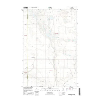
2014 Map of Tahquamenon Lakes
USGS Topo · Published 2014About this map
The Tahquamenon River winds through this reach of the Upper Peninsula, carving a path through a dense network of glacial lakes and wetlands along the border of Schoolcraft and Luce Counties. The landscape is defined by the presence of Danaher Plains and a complex hydrography including the Tahquamenon Lakes, Belle Lakes, and specialized features like Bennet Springs. Settlement is minimal, represented by the presence of Camp Seven Alke and a network of specialized routes such as the Belle Lake Trl and Clark Trl. This area reflects the mid-20th-century character of Michigan's wilderness, where naming conventions like Devils Hollow Lake, Grass Slough, and Fur Farm Lake suggest a history tied to seasonal camps, trapping, and the logging industry's legacy.
Find a feature on this map
47 named features on this map. Tap any name to fly to it.
Don’t see what you’re looking for? This feature index may not catch every label — zoom into the map to look around manually.
Map Details
Editions of this 2014 Tahquamenon Lakes Map
This is the sole edition of this map. No revisions or reprints were ever made.
Other maps of this area

1931 · Seney SW
USGS Topo · 1:31,680

1931 · Seney NW
USGS Topo · 1:31,680

1931 · Seney SE
USGS Topo · 1:31,680

1954 · Sault Sainte Marie
USGS Topo · 1:250,000

1956 · Sault Sainte Marie
USGS Topo · 1:250,000

1957 · Sault Sainte Marie
USGS Topo · 1:250,000

1958 · Sault Sainte Marie
USGS Topo · 1:250,000
1968 · Nawakwa Lake
USGS Topo · 1:24,000

1968 · Muskallonge Lake SW
USGS Topo · 1:24,000
1968 · Grand Marais SE
USGS Topo · 1:24,000