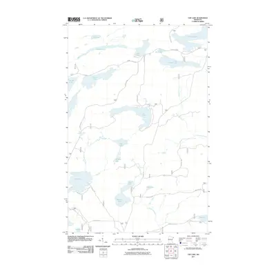
2011 Map of Tait Lake
USGS Topo · Published 2011About this map
Tait Lake and its surrounding boreal hydrology define this portion of the Superior National Forest area in Cook County. The landscape is characterized by an intricate network of glacial lakes and waterways, including the winding Tait River and the headwaters of Mississippi Creek. A significant east-west corridor known as The Grade suggests the legacy of early 20th-century logging infrastructure, now serving as a primary access route through the dense woods. Smaller water bodies like Mistletoe Lake, Williams Lake, and Lichen Lake are connected by seasonal streams and forest roads such as Clara Lake Rd and Porters Blvd. The map reveals a high concentration of named lakes in the northern half, such as Kinogami Lake and Cascade Lake, contrasting with the more creek-dominated southern terrain where Mistletoe Creek and Murmur Creek Rd are found.
Find a feature on this map
32 named features on this map. Tap any name to fly to it.
Don’t see what you’re looking for? This feature index may not catch every label — zoom into the map to look around manually.
Map Details
Editions of this 2011 Tait Lake Map
This is the sole edition of this map. No revisions or reprints were ever made.
Other maps of this area

1919 · Brule Lake
USGS Topo · 1:62,500

1919 · Lutsen
USGS Topo · 1:62,500

1954 · Two Harbors
USGS Topo · 1:250,000

1955 · Tofte
USGS Topo · 1:62,500

1957 · Two Harbors
USGS Topo · 1:250,000

1958 · Two Harbors
USGS Topo · 1:250,000

1958 · Deer Yard Lake
USGS Topo · 1:24,000

1959 · Lutsen
USGS Topo · 1:24,000

1960 · Tait Lake
USGS Topo · 1:24,000

1960 · Mark Lake
USGS Topo · 1:24,000