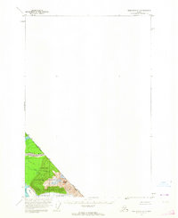
1960 Map of Taku River C-5
USGS Topo · Published 1964About this map
The International Boundary between Alaska and British Columbia cuts diagonally across this 1960 survey, marking a stark division through the glacier-sculpted terrain. The massive Wright Glacier dominates the southern portion of the mapped area, its frozen expanse pushing toward the high elevations of the Wright Peaks. To the north, the drainage basin of the Taku River and its tributaries, including the Sittakanay River and Fish Creek, define the landscape. This portion of the Tongass National Forest remains largely untouched by development, focusing instead on the dramatic natural topography of the coastal mountains. The map provides an essential record of the glacial boundaries and watercourses as they appeared at the start of the 1960s.
Find a feature on this map
8 named features on this map. Tap any name to fly to it.
Don’t see what you’re looking for? This feature index may not catch every label — zoom into the map to look around manually.
Map Details
Editions of this 1960 Taku River C-5 Map
This is the sole edition of this map. No revisions or reprints were ever made.
Other maps of this area

1951 · Taku River B-6
USGS Topo · 1:63,360

1951 · Taku River B-5
USGS Topo · 1:63,360

1953 · Taku River
USGS Topo · 1:250,000

1960 · Taku River C-6
USGS Topo · 1:63,360

1960 · Taku River
USGS Topo · 1:250,000

1994 · Taku River B-6
USGS Topo · 1:63,360

1995 · Taku River C-6
USGS Topo · 1:63,360
2017 · Taku River B-6 NE
USGS Topo · 1:25,000
2017 · Taku River B-5 NW
USGS Topo · 1:25,000
2017 · Taku River C-5 SW
USGS Topo · 1:25,000