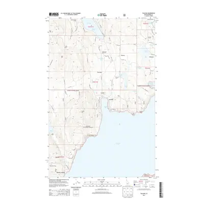
2013 Map of Talache
USGS Topo · Published 2013About this map
The western shores of Lake Pend Oreille define this Idaho landscape, where the settlements of Garfield and Talache sit between the water and the high ground of the Kanisku National Forest. The map documents a complex mix of private lakefront development and public timberlands, with numerous small lakes like Providence Lake, Gamlin Lake, and Beaver Lake tucked into the hills. Gold-mining history is etched into the local nomenclature at Gold Mtn, Gold Hill, and Gold Gulch, while more modern infrastructure is visible at the Rapoport Ranch Airport and Timber Basin Airpark Inc. The southern reach of the map shows Talache Landing and the Bimetallic Ridge, tracing the rugged transition from the shoreline at Garfield Bay to the steep elevations of Grouse Mtn.
Find a feature on this map
109 named features on this map. Tap any name to fly to it.
Don’t see what you’re looking for? This feature index may not catch every label — zoom into the map to look around manually.
Map Details
Editions of this 2013 Talache Map
This is the sole edition of this map. No revisions or reprints were ever made.
Other maps of this area

1901 · Sandpoint
USGS Topo · 1:125,000

1911 · Priest Lake
USGS Topo · 1:250,000

1911 · Sandpoint
USGS Topo · 1:125,000

1913 · Priest Lake
USGS Topo · 1:250,000

1949 · Packsaddle Mtn
USGS Topo · 1:62,500

1951 · Packsaddle Mtn
USGS Topo · 1:62,500

1951 · Elmira
USGS Topo · 1:62,500

1958 · Sandpoint
USGS Topo · 1:250,000

1963 · Sandpoint
USGS Topo · 1:250,000
1968 · Cocolalla
USGS Topo · 1:24,000