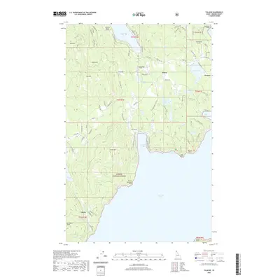
2020 Map of Talache
USGS Topo · Published 2020About this map
Lake Pend Oreille dominates the southern half of this landscape, its western shoreline marked by the settlement of Talache and the rugged contours of Bimetallic Ridge. The northern terrain is defined by a series of peaks including Gold Mtn and Gold Hill, descending toward the eastern shores near Glengary. This area reflects a legacy of extraction and remote utility, seen in the many "Gold" and "Mineral" place names alongside modern aviation nodes like Rapoport Ranch Airport and Timber Basin Airpark Inc. Within the Kaniksu National Forest, the topography rises sharply to Grouse Mtn before dropping to the sheltered waters of Garfield Bay. Numerous smaller water bodies like Mirror Lake and Providence Lake are scattered throughout the timbered highlands, connected by a network of forest roads and trails.
Find a feature on this map
92 named features on this map. Tap any name to fly to it.
Don’t see what you’re looking for? This feature index may not catch every label — zoom into the map to look around manually.
Map Details
Editions of this 2020 Talache Map
This is the sole edition of this map. No revisions or reprints were ever made.
Other maps of this area

1901 · Sandpoint
USGS Topo · 1:125,000

1911 · Priest Lake
USGS Topo · 1:250,000

1911 · Sandpoint
USGS Topo · 1:125,000

1913 · Priest Lake
USGS Topo · 1:250,000

1949 · Packsaddle Mtn
USGS Topo · 1:62,500

1951 · Packsaddle Mtn
USGS Topo · 1:62,500

1951 · Elmira
USGS Topo · 1:62,500

1958 · Sandpoint
USGS Topo · 1:250,000

1963 · Sandpoint
USGS Topo · 1:250,000
1968 · Cocolalla
USGS Topo · 1:24,000