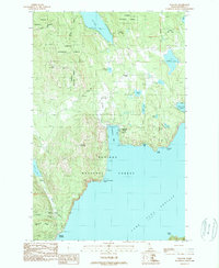
1989 Map of Talache
USGS Topo · Published 1989About this map
The western shores of Lake Pend Oreille define this late-1980s look at the rugged mining and timber country within the Kaniksu National Forest. Evidence of the region’s mineral history is prominent, centered on the Garfield (Midas) Gold Coin Mine at Garfield Bay and various prospects found along Gold Mountain and Bimetallic Ridge. The small settlement of Talache and the adjacent Talache Landing mark the site of historical lakefront activity near the mouth of Talache Creek.
Find a feature on this map
45 named features on this map. Tap any name to fly to it.
Don’t see what you’re looking for? This feature index may not catch every label — zoom into the map to look around manually.
Map Details
Editions of this 1989 Talache Map
This is the sole edition of this map. No revisions or reprints were ever made.
Other maps of this area

1901 · Sandpoint
USGS Topo · 1:125,000

1911 · Priest Lake
USGS Topo · 1:250,000

1911 · Sandpoint
USGS Topo · 1:125,000

1913 · Priest Lake
USGS Topo · 1:250,000

1949 · Packsaddle Mtn
USGS Topo · 1:62,500

1951 · Packsaddle Mtn
USGS Topo · 1:62,500

1951 · Elmira
USGS Topo · 1:62,500

1958 · Sandpoint
USGS Topo · 1:250,000

1963 · Sandpoint
USGS Topo · 1:250,000
1968 · Cocolalla
USGS Topo · 1:24,000