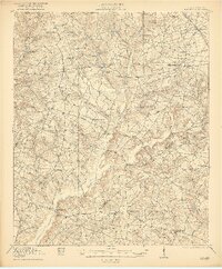
1921 Map of Talatha
USGS Topo · Published 1921About this map
Upper Three Runs and its numerous tributaries, including Johnson Fork and Reedy Branch, carve a dense network of drainages across this portion of Aiken and Barnwell counties. The settlement pattern in 1918 reflects a highly localized rural society, evidenced by the remarkable density of neighborhood institutions such as Beulah Grove School, Gum Fork School, and Hickory Grove School. Transportation is anchored by historic overland routes like Whisky Road and the Augusta and Barnwell Road, while the Southern railroad serves the northern village of Windsor. Industrial activity is represented by Thalmans Mill on the lower reaches of the basin. The landscape is also defined by spiritual centers, including Talatha Church, Rosemary Church, and Canaan Church, which likely served as the primary social hubs for the surrounding farmsteads and timber tracts of the early twentieth-century South Carolina interior.
Find a feature on this map
49 named features on this map. Tap any name to fly to it.
Don’t see what you’re looking for? This feature index may not catch every label — zoom into the map to look around manually.
Map Details
Editions of this 1921 Talatha Map
3 editions found
Other maps of this area

1919 · Allendale
USGS Topo · 1:62,500

1920 · Ellenton
USGS Topo · 1:48,000

1920 · Greens Cut
USGS Topo · 1:62,500

1920 · Aiken
USGS Topo · 1:48,000

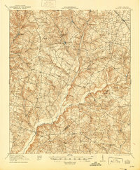
1920 · Talatha
USGS Topo · 1:48,000

1921 · Augusta
USGS Topo · 1:62,500

1921 · Aiken
USGS Topo · 1:62,500

1921 · Talatha
USGS Topo · 1:62,500

1921 · Ellenton
USGS Topo · 1:62,500

1923 · Williston
USGS Topo · 1:48,000