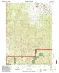
1996 Map of Talent
USGS Topo · Published 1998About this map
Talent sits at the nexus of the Southern Pacific rail line and the Pacific Highway, serving as a central hub for the surrounding agricultural and timbered landscape. The infrastructure of the Talent Middle Canal, Talent West Canal, and Talent Lateral illustrates a highly managed water system designed to support the valley's development. To the south, the terrain rises sharply into the Rogue River National Forest, where landmarks like Bald Mountain and Point Mountain overlook a complex network of drainages including Wagner Creek and Anderson Creek.
Find a feature on this map
53 named features on this map. Tap any name to fly to it.
Don’t see what you’re looking for? This feature index may not catch every label — zoom into the map to look around manually.
Map Details
Editions of this 1996 Talent Map
This is the sole edition of this map. No revisions or reprints were ever made.
Other maps of this area

1891 · Ashland
USGS Topo · 1:250,000

1893 · Ashland
USGS Topo · 1:250,000

1897 · Ashland
USGS Topo · 1:250,000

1938 · Medford
USGS Topo · 1:125,000

1954 · Medford
USGS Topo · 1:62,500

1954 · Lakecreek
USGS Topo · 1:62,500

1954 · Talent
USGS Topo · 1:62,500

1954 · Ashland
USGS Topo · 1:62,500

1955 · Medford
USGS Topo · 1:250,000

1957 · Medford
USGS Topo · 1:250,000