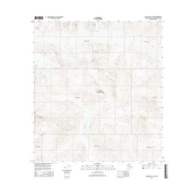
2016 Map of Talkeetna D-1 NW
USGS Topo · Published 2016About this map
Denali National Park encompasses a significant portion of this high-elevation Alaskan landscape, where the terrain is defined by steep glacial valleys and sharp mountain peaks. The northern reaches of the quadrangle are dominated by the headwaters of the Coffee River, which cuts through the central valley, and Crystal Cr to the east. A prominent geographic landmark, Mt Mazama, stands at the western edge of the park boundary. This 2016 survey by the U.S. Geological Survey illustrates the intersection of several township and range boundaries, including t33n r6w and t22s r15w, which mark the transition between different regional survey systems in the remote wilderness of the Matanuska-Susitna Borough.
Find a feature on this map
12 named features on this map. Tap any name to fly to it.
Don’t see what you’re looking for? This feature index may not catch every label — zoom into the map to look around manually.
Map Details
Editions of this 2016 Talkeetna D-1 NW Map
This is the sole edition of this map. No revisions or reprints were ever made.
Other maps of this area

1950 · Talkeetna
USGS Topo · 1:250,000

1951 · Talkeetna
USGS Topo · 1:250,000

1952 · Mount McKinley
USGS Topo · 1:250,000

1954 · Mount McKinley A-2
USGS Topo · 1:63,360

1954 · Mount McKinley A-1
USGS Topo · 1:63,360

1958 · Talkeetna D-2
USGS Topo · 1:63,360
1958 · Talkeetna D-1
USGS Topo · 1:63,360

1958 · Talkeetna
USGS Topo · 1:250,000

1958 · Mount McKinley
USGS Topo · 1:250,000

1965 · Talkeetna
USGS Topo · 1:250,000