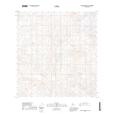
2023 Map of Talkeetna Mountains A-2 SW
USGS Topo · Published 2023About this map
Oshetna River headwaters dominate the northwest corner of this remote Alaskan interior landscape, where glacial runoff feeds a complex network of named tributaries. The high-altitude terrain is defined by the convergence of Caribou Creek and its many feeders, including Mazuma Creek and Whistler Creek. These drainages represent the raw topography of the Matanuska-Susitna region as documented by the U.S. Geological Survey in the early 21st century. The map provides a precise look at the drainage patterns of Cardioceras Creek and Cadoceras Creek, which flow through the eastern reaches of the quadrangle. With no established roads or settlements recorded, the map serves as a primary reference for the natural hydrology and land divisions of the Talkeetna Mountains.
Find a feature on this map
14 named features on this map. Tap any name to fly to it.
Don’t see what you’re looking for? This feature index may not catch every label — zoom into the map to look around manually.
Map Details
Editions of this 2023 Talkeetna Mountains A-2 SW Map
This is the sole edition of this map. No revisions or reprints were ever made.
Other maps of this area

1948 · Anchorage D-3
USGS Topo · 1:63,360

1948 · Anchorage D-2
USGS Topo · 1:63,360

1950 · Talkeetna Mountains
USGS Topo · 1:250,000

1951 · Anchorage
USGS Topo · 1:250,000

1951 · Talkeetna Mountains A-2
USGS Topo · 1:63,360

1951 · Talkeetna Mountains A-3
USGS Topo · 1:63,360

1952 · Anchorage D-2
USGS Topo · 1:63,360

1952 · Anchorage D-3
USGS Topo · 1:63,360
1952 · Talkeetna Mountains A-2
USGS Topo · 1:63,360
1952 · Talkeetna Mountains A-3
USGS Topo · 1:63,360