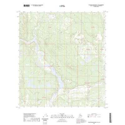
2023 Map of Talkeetna Mountains D-1 NE
USGS Topo · Published 2023About this map
The Susitna River carves a dominant path through this portion of the Matanuska-Susitna Borough, defining a complex landscape of glacial drainage and shifting watercourses. Its broad valley floor is joined by several significant tributaries, including the southern reaches of Waterfall Creek and the meandering path of Clearwater Creek as it flows from the east. The terrain is characterized by the convergence of multiple township boundaries, including t33n r12e and t13n r10w, which trace the administrative layout of this interior wilderness. Along the southern edge, Coal Creek adds to the network of waterways that have shaped the geological character of the Talkeetna Mountains region. This survey highlights a remote environment where the natural movement of water remains the primary architect of the land, showing the braided channels and elevation changes that define the Upper Susitna basin.
Find a feature on this map
12 named features on this map. Tap any name to fly to it.
Don’t see what you’re looking for? This feature index may not catch every label — zoom into the map to look around manually.
Map Details
Editions of this 2023 Talkeetna Mountains D-1 NE Map
This is the sole edition of this map. No revisions or reprints were ever made.
Other maps of this area

1949 · Healy A-1
USGS Topo · 1:63,360

1950 · Talkeetna Mountains
USGS Topo · 1:250,000

1950 · Mount Hayes
USGS Topo · 1:250,000

1950 · Mount Hayes A-6
USGS Topo · 1:63,360

1951 · Healy
USGS Topo · 1:250,000

1951 · Gulkana
USGS Topo · 1:250,000

1951 · Mount Hayes
USGS Topo · 1:250,000

1951 · Gulkana D-6
USGS Topo · 1:63,360

1951 · Talkeetna Mountains D-1
USGS Topo · 1:63,360
1952 · Talkeetna Mountains D-1
USGS Topo · 1:63,360