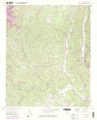
1971 Map of Talking Rock
USGS Topo · Published 1986About this map
Talking Rock and the surrounding North Georgia uplands are defined by a complex network of waterways and early industrial markers. The Seaboard railroad line provides a corridor for industry, passing through Whitestone where several Quarries and a Mine are situated along Talona Creek. This era of the landscape shows the coexistence of established agriculture and emerging recreation, with the Coosawattee R and Carters Lake featuring a Boat Ramp and Picnic Area in the northwest. Local family and community history is anchored by numerous rural institutions, including the Southwestern Sch, the Ball Creek Ch, and the landmark Carns Mill. Distinctive topographic features like Sevenmile Ridge and Pine Mountain separate the drainages of Scarecorn Creek and Talking Rock Creek, while an Old Railroad Grade north of the main settlement hints at earlier transportation alignments.
Find a feature on this map
51 named features on this map. Tap any name to fly to it.
Don’t see what you’re looking for? This feature index may not catch every label — zoom into the map to look around manually.
Map Details
Editions of this 1971 Talking Rock Map
3 editions found
Other maps of this area

1886 · Dalton
USGS Topo · 1:125,000

1888 · Ellijay
USGS Topo · 1:125,000

1890 · Suwanee
USGS Topo · 1:125,000

1890 · Cartersville
USGS Topo · 1:125,000

1891 · Cartersville
USGS Topo · 1:125,000

1892 · Ellijay
USGS Topo · 1:125,000

1892 · Dalton
USGS Topo · 1:125,000

1894 · Suwanee
USGS Topo · 1:125,000

1896 · Cartersville
USGS Topo · 1:125,000

1897 · Dalton
USGS Topo · 1:125,000