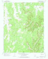
1970 Map of Tall Mountain
USGS Topo · Published 1977About this map
The Navajo National Monument (Keet Seel Ruin) anchors the southeastern corner of this landscape, highlighting a region defined by ancient ancestral Puebloan architecture. This 1970s survey captures the intricate relationship between the high desert terrain and the archaeological sites tucked into the alcoves of Long Canyon and Nokai Canyon. Numerous cliff dwellings are documented alongside the distinctive Calamity Cave Cliff Dwelling, illustrating the deep human history within the Navajo Indian Reservation.
Find a feature on this map
20 named features on this map. Tap any name to fly to it.
Don’t see what you’re looking for? This feature index may not catch every label — zoom into the map to look around manually.
Map Details
Editions of this 1970 Tall Mountain Map
2 editions found
Other maps of this area

1883 · Marsh Pass
USGS Topo · 1:250,000

1892 · Marsh Pass
USGS Topo · 1:250,000

1952 · Shato Spring 1 NE
USGS Topo · 1:24,000

1952 · Agathla Peak 2 SW
USGS Topo · 1:24,000

1952 · Agathla Peak 2 NW
USGS Topo · 1:24,000

1952 · Boot Mesa
USGS Topo · 1:62,500

1956 · Marble Canyon
USGS Topo · 1:250,000

1959 · Marble Canyon
USGS Topo · 1:250,000

1961 · Marble Canyon
USGS Topo · 1:250,000

1968 · Marsh Pass
USGS Topo · 1:24,000