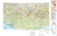
1988 Map of Tallahassee
USGS Topo · Published 1988About this map
Tallahassee stands as the primary hub of this 1988 survey, characterized by the dense clustering of the Florida State Capitol, Florida State University, and Florida A&M University. The map documents a complex landscape where the industrial and civic activity of the state capital transitions into the vast timberlands of the Apalachicola National Forest. This era shows a well-established transportation network, with I-10 and Us-90 cutting across the Panhandle, while the Apalachicola Northern RR and Bay Line RR maintain older industrial corridors connecting inland settlements like Marianna and Quincy to the coast.
Find a feature on this map
238 named features on this map. Tap any name to fly to it.
Don’t see what you’re looking for? This feature index may not catch every label — zoom into the map to look around manually.
Map Details
Editions of this 1988 Tallahassee Map
2 editions found
Other maps of this area

1935 · De Funiak Springs
USGS Topo · 1:48,000

1936 · Point Washington
USGS Topo · 1:48,000

1938 · De Funiak Springs
USGS Topo · 1:62,500

1939 · Point Washington
USGS Topo · 1:62,500

1940 · Tallahassee
USGS Topo · 1:62,500

1940 · Arran
USGS Topo · 1:62,500

1942 · Enterprise
USGS Topo · 1:125,000

1942 · Tallahassee
USGS Topo · 1:62,500

1943 · Arran
USGS Topo · 1:62,500

1943 · Beacon Beach
USGS Topo · 1:31,680