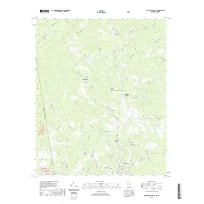
2020 Map of Tallapoosa North
USGS Topo · Published 2020About this map
The Tallapoosa River meanders across this landscape north of Tallapoosa, marking a region where family-named roads and rural settlements define the geography. This modern survey reflects the enduring nature of the Haralson County landscape, where the state line between Georgia and Alabama divides the western portion of the map. Local history is anchored by several long-standing burial grounds such as Mount Zion West Cem, New Canaan Cem, and Salem Cem, often located near crossroads and small community centers like Steadman and Poplar Springs. The river is spanned by several notable crossings, including Adderholds Bridge and McBride Bridge, which facilitate a network of roads like Old Jacksonville Rd and Salem Church Rd. Numerous small tributaries like Terrapin Cr and Beach Creek feed the main river, while man-made features like Spearman Lake and East Wards Lake dot the countryside.
Find a feature on this map
90 named features on this map. Tap any name to fly to it.
Don’t see what you’re looking for? This feature index may not catch every label — zoom into the map to look around manually.
Map Details
Editions of this 2020 Tallapoosa North Map
This is the sole edition of this map. No revisions or reprints were ever made.
Other maps of this area

1889 · Tallapoosa
USGS Topo · 1:125,000

1892 · Tallapoosa
USGS Topo · 1:125,000

1897 · Tallapoosa
USGS Topo · 1:125,000

1953 · Atlanta
USGS Topo · 1:250,000

1957 · Atlanta
USGS Topo · 1:250,000

1958 · Atlanta
USGS Topo · 1:250,000

1958 · Carrollton
USGS Topo · 1:62,500

1958 · Buchanan
USGS Topo · 1:62,500

1965 · Tallapoosa South
USGS Topo · 1:24,000

1966 · Tallapoosa North
USGS Topo · 1:24,000