
1966 Map of Tallapoosa North
USGS Topo · Published 1967About this map
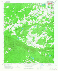
The Tallapoosa River winds through the eastern and southern portions of this landscape, its path forming significant bends near the settlement of Poplar Springs. The terrain is marked by a network of rural creek valleys, including Mann Creek and Little Mann Creek, which dictate the placement of local roads and farmsteads. Cultural life in the mid-1960s was centered around numerous small congregations and educational sites, such as the West Haralson Sch, Bethany Ch, and Ebenezer Ch. The western edge of the map follows the jagged border between Alabama and Georgia, crossing into the Talladega National Forest. In this borderland, the transition between Cleburne County and Haralson County is interspersed with family-named water bodies like Spearman Lake and Pope Lake, reflecting a community deeply tied to the land and its many small tributaries.
Find a feature on this map
34 named features on this map. Tap any name to fly to it.
Don’t see what you’re looking for? This feature index may not catch every label — zoom into the map to look around manually.
Map Details
Editions of this 1966 Tallapoosa North Map
This is the sole edition of this map. No revisions or reprints were ever made.
Other maps of this area

1889 · Tallapoosa
USGS Topo · 1:125,000

1892 · Tallapoosa
USGS Topo · 1:125,000

1897 · Tallapoosa
USGS Topo · 1:125,000

1953 · Atlanta
USGS Topo · 1:250,000

1957 · Atlanta
USGS Topo · 1:250,000

1958 · Atlanta
USGS Topo · 1:250,000

1958 · Carrollton
USGS Topo · 1:62,500

1958 · Buchanan
USGS Topo · 1:62,500

1965 · Tallapoosa South
USGS Topo · 1:24,000
1966 · Benedict
USGS Topo · 1:24,000